|
District Profile Geographical Position North Latitude between
12°15' and 13°15' The district is surrounded by Kancheepuram district in the South, Vellore district in the West. Bay of Bengal in the East and Andhra Pradesh State in the North. The district spreads over an area of about 3422 Sq.kms. An insight into the early history of this region shows that the region was reined by kingdoms such as the Pallavas, the Golkondas, the Mughals, the French, the Dutch and also the British. Physical FeaturesThe Coastal region is mostly flat while certain areas in Tiruttani and Pallipattu taluks are undulated and even hilly. The types of soil predominantly found are red non-calcareous and coastal alluvial. Also found are sandy soil mixed with soda or other alkali. The soil found in the coastal region is of the erinaceous type (sandy), suitable for casuarinas plants. PopulationThe population of the district is 27,38,866 persons with 51% male and 49% female as per the census 2001 (provisional). Population Distribution
Vital Statistics
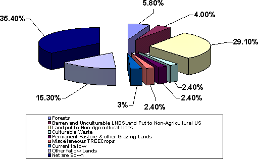
The district has a mixture of urban and rural characteristics. The Eastern part of Tiruvallur district is dominated by urban characteristics while the Southern and Northern part of the district has influence of Andhra culture due to its position. The languages spoken in the district are Tamil, Telugu, Hindi, Malayalam and Urdu. The district is dominated by the Hindus while people belonging to other religions are also present. Administrative StructureThe district has been divided into three revenue divisions viz, Tiruvallur, Tiruttani and Ponnari. There are three taluks under Thiruvallur division, two taluks under Tiruttani divisions and three taluks under Ponneri division. There are 46 firkas and 820 revenue villages. Likewise there are 14 blocks, 6 Municipalities and 19 town panchayats which implement rural development activities. Land Use PatternThe total geographical area of the district is 3,42,243 hectares of which not sown area constitute 35% whereas forest covers 5.8% of the total area. The nine-fold clarification of the land are pattern is given below. Land use pattern
 Rainfall and ClimateThe average rainfall of the district is 1104.4 mm, of which the North East monsoon contributes to the tune of 690 mm. The actual rainfall received during the agricultural year 2001 - 02 is 1164.4mm.
The average temperature of the district is Like other parts of Tamil Nadu, hot climate prevails during the month of April - May and humid climate during the rest of the year except December - February when it is slightly cold. AgricultureThe main occupation of the district is agriculture and allied activities Nearly 47% of the total work force is engaged in the agricultural sector. The major crops grown in the district are rice, cumbu - ragi, green gram, black gram, sugar cane and groundnut. Apart from this, certain horticultural crops like mango, guava and vegetables have also bean cultivated successfully. The average area, production and productivity of the Principal crops are as follows: 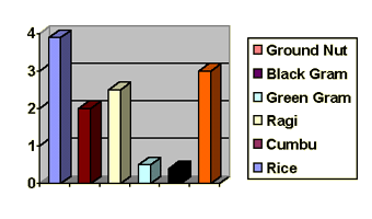
IrrigationApart from seasonal rivers like Kesathaliar, Aravar, Nandi, Kallar, Coovam and Buckhingham Canal there is no perennial river in the district. Since these seasonal rivers are not sufficient, irrigation through tanks, tube wells and open wells are very common. 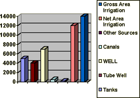
Animal Husbandry and FisheriesAnimal husbandry is a subsidiary occupation of the district due to the presence of a number of small and marginal farmers. Presently, there are four Government Schemes in operation Viz., Backyard poultry farm, Buffalo Rearing Scheme, Special Animal Husbandry Programme and special campaign to protect animals. There are 5 Veterinary Hospitals, 24 Veterinary Dispensaries, 77 sub-centres and 14 mobile veterinary units catering to the needs of the farming community. The total coastal area of the district is about 49803 ha and has a coast line of 80 kms for marine fisheries. Prawn/shrimp culture is famous at the coast line of Gummidipoondi and Minjur. The total fish production is to the tune of 11372 tonnes. Mineral ResourcesThe district does not contain any precious mineral. However it has a few varieties of major and minor minerals.
IndustriesTiruvallur district is one of the fastest developing districts in Tamil Nadu in terms of Industrial Development. The district has many leading industries like Madras Refineries, Madras Fertilizers, Manali Petro Chemicals, MRF, Ashok Leyland, TI Cycles, Britannia India Ltd, Parry India Ltd and Hindustan Motors. It also boasts of the Ennore Thermal Power Station and the Avadi Tank Factory. The District has 16 Industrial Estates, all in operation : 11 developed by the Government and 5 by Private Organisation. Government
Private
This district has 16940 Small Scale Industries, notable among them being food, wood, textile, chemical, engineering, non-metallic and leather industries. 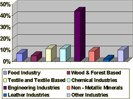 EducationSince this district is adjacent to the city of Chennai, there are remarkable number of Educational Institutions in the district. Many professional institutions particularly the veterinary university add honour to this district is the field of education. The literacy rate is about 68% of the total population as per 2001 census (provisional). The list of educational Institutions are given below.
Work ForceThe table given below presents details on workforce in the district. While the rural workers are employed in agriculture and allied activities, the urban workforce is employed in industries.
|
||||||||||||||||||||||||||||||||||||||||||||||||||||||||||||||||||||||||||||||||||||||||||||||||||||||||
Designed & Powered By Realtime Solutions - Tiruvallur